Would you live in Moresby Heights, Geraldton's proposed new suburb?
/ If you didn't unwrap The Midwest Times when it landed on your driveway on Feb 20 and read the public notices section, you might have missed the advertisement about a proposed new development known as Moresby Heights.
This Tuesday it will be put to a vote by council, after public submissions closed back on March 21.
The proposed new development will be located 10km north east of the Geraldton CBD, 4km from the coast, at the foot of the Moresby Range. It could home approx 4000 - 5000 people, about the population of Carnarvon.
The structure plan put to the city by the developers says:
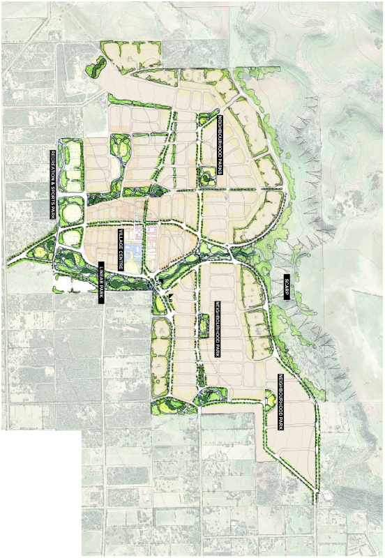
The structure plan proposes development of the site for predominantly residential purposes, supported by a neighbourhood centre, primary school and public open space. It also proposes areas of regional and district open space, in support of the City of Greater Geraldton’s planning strategies and requirements, and a tourism node at the top of the Moresby Range scarp.
The city staff are recommending to council to approve the proposal, despite several objections from nearby landholders.
Some of the feedback included:
- Destroy rural setting and current amenity of the area.
- Increased traffic, noise and light.
- Suitable land elsewhere in Geraldton for subdivision.
- Should be connected to sewerage scheme.
- Development is too dense.
- Impacts on visual landscape amenity.
- Well thought out and environmentally sensitive plan.
- Tourist site should be served by a road from the east not up the escarpment.
- Subdivision at a higher density than that recommended by the Moresby Range Management Plan.
- Tourism sites could set a precedent for future development in areas of high visibility.
- Loss of native fauna.
- The adjacent Waggrakine Rural Residential area cannot subdivide to this level and these developers will be unfairly favoured by being able to subdivide the land into suburban sized blocks.
- Allow only 2 – 4 ha lots.
Click here to read all the feedback submissions in full, and responses from the CGG.
One of the consistent themes within the submissions to council regarding the development is that there simply isn't the demand in the region to warrant more property coming on to the market; other developments remain undersold, many properties sit on the market for a long time before selling, and many similar properties are selling for hundreds of thousands of dollars below what they were 7 years ago.
Acknowledging the depressed state of the market, the city says the land may remain "as is" for some time; that is to say, even if approved, the land may remain undeveloped for quite some time until the demand warrants the investment.
But given the CGG council have a plan to make Geraldton suitable for 80,000 to 100,000 people, they believe "forward planning for the site should be progressed to enable the timely release of land" in the future. "The cost of developing the site largely falls to the developer, not the City."
The plan has been in the works for some time. It was presented to Councillors back in May 2011.
The people behind the new suburb development include Paul Dossiter, Site Construction Manager at CSI Phill's Creek; V Neil; Seventh Wave Enterprises Pty Ltd which is owned by Ashley Newton, Christopher Newton and Dana Newton. Other stakeholders are also named in the LOCAL STRUCTURE PLAN by CLE Town Planning and Design
From the Tuesday's agenda documentation again:
The site is surrounded by Rural Residential developments to the south and west, which are subject to the Waggrakine Rural Residential Structure Plan. Land to the north and east is zoned ‘Rural’ and is subject to low intensity agricultural use.
The development of the site for urban purposes will require treatment of these areas to provide a transition in intensity of development. This has been addressed through the provision of rural residential and larger residential lots and / or open space around the periphery of the development.
The development will essentially represent an expansion of the Geraldton urban area to its north-easterly limits. Its separation from existing urban areas by the Waggrakine Rural Residential area will give it something of a ‘village’ character; however its proximity to Geraldton means that it will effectively form a suburb of the city.
The proposed Local Structure Plan provides for development of the site to accommodate:
- 79 ha of ‘regional’ open space, protecting the Moresby Range;
- A neighbourhood commercial centre and abutting Primary School, roughly in the centre of the site;
- Urban residential neighbourhoods both north and south of the neighbourhood centre, with potential for higher density in close proximity to the centre;
- Low density and Rural Residential around the periphery of the residential neighbourhoods, providing for a diversity of lot types and a graduation in density from adjoining rural residential and rural areas;
- An integrated network of parkland throughout the development, protecting areas of environmental significance, providing for integrated urban water management, and providing for local recreation and amenity to service the subdivision;
- 33 ha of District Open Space, provided in a linear spine through the development to link to the Moresby Range, and in a consolidated 14 ha block in the west of the site, to provide for District Recreation;
- Two potential tourism facilities, including one on the Range Tops, where a low profile development could be designed to nestle in behind the Range ‘edge’ where it would be visually unobtrusive, but could benefit from the magnificent ocean views this location affords. In addition to accommodation, the site might also accommodate a cafe or restaurant, or possibly even a small tavern which would provide an attraction to the local Geraldton community as well as more distant visitors. The second, lower site appears more suited to eco-chalets or similar self-contained, low intensity accommodation.